


Machu Picchu Elevation: How High Is It and Will You Feel the Altitude?

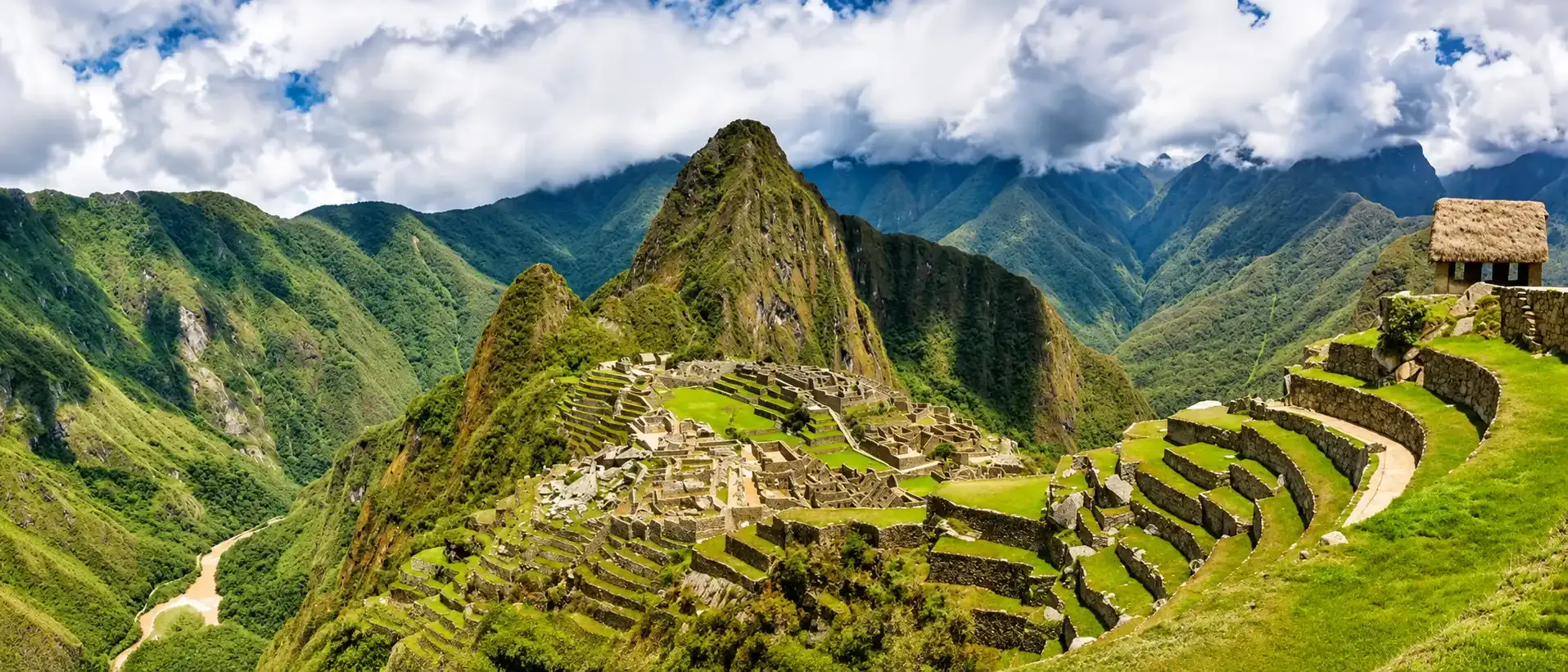
Machu Picchu sits at 2,430 m (7,972 ft) above sea level, almost 1,000 m (3,180 ft) lower than Cusco. Few people feel the altitude at the ruins themselves. The real test is Cusco, at 3,399 m (11,152 ft), where about 4 in 10 visitors who fly in get mild altitude sickness.
- 2,430 m
- Machu Picchu (7,972 ft)
- 3,399 m
- Cusco (11,152 ft)
- 4,215 m
- Inca Trail high pass (13,829 ft)
- 1 to 2 nights
- lower down before Cusco
In this guide
How High Is Machu Picchu? Elevation in Feet and Meters
The citadel stands at 2,430 m, or 7,972 ft. That is the figure used by UNESCO and by the official ticket site of Peru's Ministry of Culture, and the one we use on every page.
You may see other numbers. The Ministry itself publishes five figures between 2,430 and 2,453 m (7,972 to 8,048 ft), because each one measures a different spot. The highest, 2,453 m, belongs to the Sacred Plaza beside the Main Temple.
The site spreads over a ridge, so it has no single height. Its lower terraces drop toward the river and its upper buildings climb toward the Guardhouse. For planning, 2,430 m is the number that matters.
Far below, the Urubamba river runs through the canyon at about 2,000 m. The citadel sits roughly 400 m above it, which is why the bus ride up from Aguas Calientes takes 25 minutes of switchbacks.
Machu Picchu Elevation Compared to Cusco
Cusco is where almost every trip starts, and it is much higher. The main square, the Plaza de Armas, sits at 3,399 m (11,152 ft). The airport is at 3,310 m (10,860 ft).
- 3,399 m
- Cusco, Plaza de Armas
- 3,310 m
- Cusco airport
- 2,430 m
- Machu Picchu
- 969 m
- difference (3,180 ft)
Many people expect the opposite. Photos of Machu Picchu above the clouds suggest a summit, but you go downhill to reach it, from the cold highlands of Cusco into the warm cloud forest.

Why Cusco feels so much harder
The air holds the same 21% of oxygen at any height. What changes is the pressure. With less pressure, every breath carries fewer molecules of oxygen into your lungs.
By our estimate from the standard atmosphere, each breath at Machu Picchu carries about 74% of the oxygen it would at sea level. In Cusco it carries about 66%, and on the Inca Trail high pass about 59%.
You also sleep in Cusco, and the body struggles most at night. The CDC notes that day trips to a high place with the night spent lower are much easier on the body. That is exactly how a Machu Picchu visit works.
Elevation of Huayna Picchu and Machu Picchu Mountain
Two peaks rise above the citadel, and both can be climbed with a special ticket. A few other high points sit along the paths around the site.
| Peak or viewpoint | Elevation | Above the citadel | Round trip |
|---|---|---|---|
| Machu Picchu Mountain | 3,082 m (10,111 ft) | 652 m (2,139 ft) | 3 to 4 hours |
| Sun Gate (Intipunku) | 2,720 m (8,924 ft) | 290 m (951 ft) | On the Inca Trail |
| Huayna Picchu | 2,693 m (8,835 ft) | 263 m (863 ft) | 1.5 to 2 hours |
| Huchuy Picchu | 2,497 m (8,192 ft) | 67 m (220 ft) | About 1 hour |
Some sources give Huayna Picchu as 2,720 m. We use 2,693 m, which agrees with the height of the peak above the saddle.
Daily places are limited. In 2026 Huayna Picchu admits 400 people a day, with entry at 7 and 10 a.m., and Machu Picchu Mountain 350, with entry at 7 and 9 a.m. Both sell out weeks ahead in the dry season. The climb is described step by step in our Huayna Picchu guide.

Elevations Along the Way: Aguas Calientes, Ollantaytambo and the Sacred Valley
The road and rail trip from Cusco runs downhill almost all the way. Each stop is lower than the last until Aguas Calientes, the town at the foot of the ruins, where most visitors spend the night.
From Cusco to Machu Picchu
2,450 m (8,000 ft): the sleeping height where the CDC sees risk
- 1Cusco3,399 m (11,152 ft)Plaza de Armas
- 2Pisac2,972 m (9,751 ft)
- 3Urubamba2,871 m (9,419 ft)
- 4Ollantaytambo2,792 m (9,160 ft)Train station
- 5Aguas Calientes2,040 m (6,693 ft)Where you sleep
- 6Machu Picchu2,430 m (7,972 ft)
Not all of the Sacred Valley is low, though. Chinchero (3,762 m) and Moray (about 3,500 m) sit higher than Cusco, and the Maras salt pans almost as high. A first day tour through them is not a way down.

| Place | Elevation | Compared to Cusco |
|---|---|---|
| Chinchero | 3,762 m (12,343 ft) | 363 m higher |
| Moray | About 3,500 m (11,480 ft) | About 100 m higher |
| Pisac | 2,972 m (9,751 ft) | 427 m lower |
| Urubamba | 2,871 m (9,419 ft) | 528 m lower |
| Ollantaytambo | 2,792 m (9,160 ft) | 607 m lower |
| Aguas Calientes | 2,040 m (6,693 ft) | 1,359 m lower |
Heights of the towns are taken at their main squares or stations. Sources differ by 10 to 60 m for Moray and Ollantaytambo.
For the train itself, see our guide on how to get to Machu Picchu from Cusco, with every way in compared.
Does Machu Picchu Cause Altitude Sickness?
Rarely. The CDC puts the risk at a sleeping altitude of 2,450 m (8,000 ft) or more. Visitors don't sleep at the citadel, they sleep in Aguas Calientes at 2,040 m or in the Sacred Valley.
Cusco is a different story. Flying in means a jump from sea level to 3,300 m in about an hour, and the CDC places that kind of arrival in its high risk group, with altitude illness rates approaching 50%.
Studies at Cusco airport agree. In a survey of 991 departing travelers, 48.5% had acute mountain sickness, mostly mild. A later study of young, healthy students in Cusco found about 40%.
Who gets it
Nobody can tell in advance. We have seen travelers from lowland countries cross the Salkantay pass without a headache, and very fit people spend a day in bed in Cusco. Where you come from does not decide it.
Medicine agrees. The CDC is blunt: "Training and physical fitness do not affect risk." The best guide is how you did at altitude before, and even that is not certain.
- Speed of ascent and the height where you sleep are the main factors.
- A recent stay at altitude protects. In the Cusco survey, travelers who had been high in the previous two months did better.
- Age helps a little. People over 50, and over 60 in Cusco, had slightly lower rates.
- Fitness, sex and nationality make little or no difference.
Altitude Sickness Symptoms to Watch For
Acute mountain sickness, called soroche in Peru, feels like a hangover. It starts 2 to 12 hours after arrival, often during the first night, and fades in 12 to 48 hours if you don't go higher.
- Headache, the main sign
- Loss of appetite or nausea, sometimes vomiting
- Tiredness or weakness
- Dizziness or light headedness
Doctors score these four on the Lake Louise scale. A headache plus a few of the others means mild altitude sickness. In small children, watch for irritability, paleness and refusing food.
Warning signs that need help now
Two rare forms are dangerous. Swelling of the brain (HACE) shows as confusion, drowsiness or walking like you're drunk. Fluid in the lungs (HAPE) shows as breathlessness at rest and a wet cough. Both call for going down and getting oxygen right away.
Both are very unusual below 4,000 m, but they happen on high treks. The CDC's three rules: know the symptoms, never sleep higher with symptoms, and go down if they get worse.
How to Acclimatize Before Your Visit
Your body adapts on its own in 3 to 5 days. Everything below either buys it time or helps it along. These are the CDC recommendations, plus what we see work with our travelers.
- Sleep low first. One or two nights below 3,000 m before sleeping in Cusco. More on this in the next section.
- Take the first 48 hours easy. Walk, don't hike, and save the steep streets of San Blas for day two.
- Skip alcohol for 48 hours. It slows your breathing at night, when your body needs it most.
- Keep your usual coffee. Stopping caffeine brings a headache that is easy to mistake for soroche.
- Drink normally. Water keeps you comfortable in the dry air, but extra water does not prevent altitude sickness.
Acetazolamide (Diamox)
The one proven medicine. It speeds up acclimatization so that 3 to 5 days of adjusting take about one. The CDC dose for prevention is 125 mg every 12 hours, starting the day before you fly to Cusco.
In the US it needs a prescription, so ask your doctor before the trip. Common side effects are tingling fingers, more trips to the bathroom and flat tasting soda. A sulfa allergy is usually not a reason to avoid it, but let your doctor decide.
Coca tea
Every hotel in Cusco will offer you a cup of mate de coca, and it is a lovely welcome. As a medicine it falls short: in the Cusco studies, travelers who drank it got altitude sickness just as often.

Oxygen
Oxygen relieves a headache in about 30 minutes, and several high end hotels in Cusco pump it into some rooms. The small cans sold in pharmacies hold too little to help for more than a few breaths.
The Smart Itinerary: Sacred Valley First, Cusco Last
This is the plan we recommend to everyone visiting Machu Picchu by train, and the CDC backs it. Its 2026 guide says that in Cusco "travelers can descend to elevations lower than the airport to sleep for 1–2 nights" before going up.
- Day 1. Land in Cusco and drive straight down to the Sacred Valley. Sleep in Urubamba or Ollantaytambo, about 2,800 m.
- Day 2. Explore the valley at an easy pace. Leave Chinchero and Moray for later, as both are higher than Cusco.
- Day 3. Train to Aguas Calientes, 2,040 m. Sleep there.
- Day 4. Machu Picchu early in the morning, then the train back. Sleep in Cusco, by now partly acclimatized.
- Day 5 onward. Cusco, Rainbow Mountain and the other high places, when your body is ready for them.
Our Sacred Valley and Machu Picchu in 2 days tour follows this order, with a night in Aguas Calientes. It works best on the day you land or the day after.

Before a trek: two nights in Cusco
For the Inca Trail or Salkantay, plan at least two nights in Cusco before you start. That fits the CDC rule of two or three nights at a middle height before going higher.
There is also a practical reason. Group treks depart from Cusco, so sleeping in the valley first only works if you book a private departure. If you can add a valley night before those two in Cusco, even better.
Hiking to Machu Picchu: Elevation Profile of Each Trek
Walking in is where altitude really counts. Every trek climbs well above Cusco before it drops to Machu Picchu, and some nights are spent higher than the city.
| Trek | Days | Highest point | Highest night |
|---|---|---|---|
| Short Inca Trail | 1 or 2 | Sun Gate, 2,720 m (8,924 ft) | Aguas Calientes, 2,040 m |
| Classic Inca Trail | 4 | Dead Woman's Pass, 4,215 m (13,829 ft) | About 3,600 m |
| Salkantay trek | 4 or 5 | Salkantay Pass, 4,630 m (15,190 ft) | About 3,900 m |
| Lares trek | 3 or 4 | Ipsaycocha Pass, about 4,450 m | Depends on the route |
| Inca Jungle | 3 or 4 | Abra Malaga, about 4,316 m, by car | Below 2,000 m |
The Short Inca Trail is the only trek that never goes above Cusco. On the Inca Jungle route you reach the pass by vehicle and ride down by bike.
The Classic Inca Trail, day by day
Classic Inca Trail, 4 days
Cusco, 3,399 m (11,152 ft), where you acclimatize first
- 1Km 822,700 m (8,858 ft)Start, day 1
- 2Wayllabamba3,000 m (9,843 ft)
- 3Ayapata3,300 m (10,827 ft)Camp, night 1
- 4Dead Woman's Pass4,215 m (13,829 ft)Day 2
- 5Pacaymayo3,600 m (11,811 ft)Valley floor
- 6Runkurakay Pass3,950 m (12,959 ft)
- 7Chaquicocha3,600 m (11,811 ft)Camp, night 2
- 8Phuyupatamarca3,650 m (11,975 ft)
- 9Wiñay Wayna2,650 m (8,694 ft)Camp, night 3
- 10Sun Gate2,720 m (8,924 ft)Day 4
- 11Machu Picchu2,430 m (7,972 ft)
Day 2 is the big one: about 900 m of climbing to Dead Woman's Pass, then a long staircase down. Most people walk it in 5 to 7 hours with stops.

Salkantay
The highest of the classic routes. The first night, near Soraypampa at about 3,900 m, is 500 m above Cusco, and the pass the next morning reaches 4,630 m. Then the trail drops 1,700 m into cloud forest.
Our treks to Machu Picchu
 Classic Inca Trail 4 Days4 days · ChallengingFrom $750
 Short Inca Trail 2 Days2 days · ModerateFrom $490
 Salkantay Trek 5 Days5 days · ChallengingFrom $310


Machu Picchu Elevation vs Other Famous High Places
If you have skied in Colorado, you have probably slept higher than Machu Picchu. Vail's lodges sit at about 8,150 ft, above the ruins. Cusco is another matter: higher than any ski town in the United States.
| Place | Feet | Meters |
|---|---|---|
| Denver | 5,280 | 1,609 |
| Mexico City | 7,350 | 2,240 |
| Machu Picchu | 7,972 | 2,430 |
| Vail, lodging | 8,150 | 2,480 |
| Quito | 9,350 | 2,850 |
| Breckenridge, lodging | 9,600 | 2,925 |
| Cusco | 11,152 | 3,399 |
| La Paz | About 12,000 | About 3,650 |
| Lake Titicaca | 12,507 | 3,812 |
| Dead Woman's Pass, Inca Trail | 13,829 | 4,215 |
| Pikes Peak | 14,115 | 4,302 |
| Mount Whitney | 14,505 | 4,421 |
| Salkantay Pass | 15,190 | 4,630 |
| Rainbow Mountain | 16,522 | 5,036 |
| Everest Base Camp, south side | About 17,600 | About 5,364 |
Peru's high trails in bold. Lodging heights for Vail and Breckenridge are the ones the CDC uses.
The comparison that surprises people most: the Salkantay Pass is higher than Mount Whitney, the tallest peak in the lower 48 states. And Dead Woman's Pass falls less than 100 m short of the top of Pikes Peak.
Frequently Asked Questions
Is Machu Picchu higher than Cusco?
No. Machu Picchu is at 2,430 m (7,972 ft) and Cusco at 3,399 m (11,152 ft), so the ruins are about 970 m (3,180 ft) lower. The trip from Cusco runs downhill.
Can you get altitude sickness at Machu Picchu?
It is unlikely at the ruins. They sit just below the 2,450 m (8,000 ft) sleeping height where the CDC sees risk, and visitors sleep lower, in Aguas Calientes. Cusco is where most people feel the altitude.
Do you need oxygen at Machu Picchu?
No. Oxygen only helps to treat altitude sickness, and few people get it at Machu Picchu. The small cans sold in pharmacies hold too little to make a lasting difference.
Is Machu Picchu higher than Denver?
Yes, by about 2,690 ft (820 m). Denver sits at 5,280 ft and Machu Picchu at 7,972 ft. It is still lower than the ski lodges of Vail.
How long should I acclimatize in Cusco?
Your body adjusts in 3 to 5 days. For a train visit, spend your first one or two nights in the Sacred Valley and Cusco at the end. Before the Inca Trail or Salkantay, plan at least two nights in Cusco.
Can kids go to Machu Picchu?
Yes, and many do. Children are as likely as adults to get altitude sickness, so follow the same lower first plan and watch for irritability, paleness and refusing food. Ask your pediatrician before giving any medicine.
Does being fit protect me from altitude sickness?
No. The CDC states that training and physical fitness do not affect risk. Fit people can still get a headache in Cusco. They just recover faster on the trail.
What is the highest point of the Inca Trail?
Dead Woman's Pass, called Warmiwañusca in Quechua, at 4,215 m (13,829 ft). Hikers cross it on day 2 of the classic 4 day route.
How we checked this guide
This guide comes from what we see while guiding these routes every week. Prices, schedules and rules were checked against the official sites below.
We sell the Sacred Valley tour and the treks linked on this page. The medical facts come from the CDC and published studies. This article is general information, not medical advice: check with your doctor before the trip.
- UNESCO World Heritage Centre, Historic Sanctuary of Machu Picchu
- Ministry of Culture of Peru, official ticket site
- CDC Yellow Book 2026, High Altitude Travel and Altitude Illness
- Salazar et al., altitude sickness in travelers to Cusco, Journal of Travel Medicine 2012
- Wilderness Medical Society guidelines on altitude illness, 2024 update
Last checked:

Jorge Suyo
Director and trekking guideJorge Suyo is a trekking guide and the person who leads Inca Outdoors. He knows these trails from walking them with groups, and that experience shapes how each trip is planned.
Meet the team

