


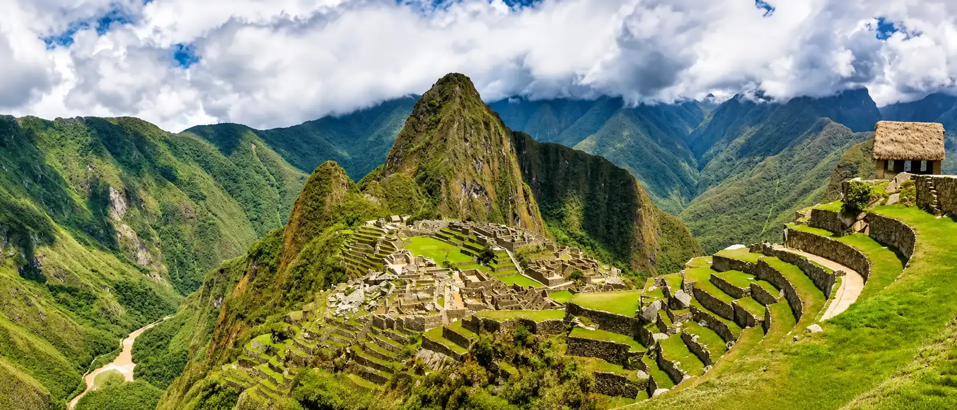
Machu Picchu Map: Where It Is and How the Circuits Work

Machu Picchu is in southern Peru, in the Cusco region, about 75 km (47 miles) northwest of Cusco on a ridge above the Urubamba river. Inside, you follow one of 3 circuits and 10 fixed routes, chosen when you buy the ticket. For a first visit, Circuit 2 shows the most.
- Peru
- Cusco region
- 75 km
- from Cusco, straight line
- 3 circuits
- 10 routes, one way
- 2.5 hours
- on the standard routes
In this guide
Where Is Machu Picchu Located?
Machu Picchu is in Peru, in the Cusco region, the province of Urubamba and the district of Machupicchu. The ruins sit at 13°09′48″ S and 72°32′44″ W, on the eastern slope of the Andes where the mountains drop toward the Amazon.
The Inca city stands on a narrow ridge between two peaks: Machu Picchu Mountain to the south and Huayna Picchu, the peak in every photo, to the north. The Urubamba river loops around three sides of the ridge, hundreds of meters below.
Machu Picchu on the map of South America
- 1LimaCapital, on the Pacific coast
- 2Machu Picchu75 km from Cusco, in the Andes
Natural Earth
It is not a lone ruin. The city is the heart of the Historic Sanctuary of Machu Picchu, 32,592 hectares of mountains and cloud forest protected since 1981. UNESCO listed it in 1983 as one of the few sites in the world that are both cultural and natural heritage.
People often place it in Mexico or Bolivia. The mix up comes from Chichén Itzá, its neighbor on the list of New Seven Wonders, and from Lake Titicaca, which Peru shares with Bolivia. Machu Picchu is entirely in Peru.
Machu Picchu on a Map of Peru
Every trip starts in Cusco, the old Inca capital. From there the rail line and the river run northwest through the Sacred Valley and into a gorge that ends at Aguas Calientes, the town at the foot of the ruins.
From Cusco to Machu Picchu
- Railway
- Urubamba river
- Historic Sanctuary
- 1CuscoAirport and the start of every trip
- 2PoroyTrain station 20 minutes from Cusco
- 3ChincheroNew airport under construction
- 4PisacSacred Valley
- 5UrubambaSacred Valley
- 6OllantaytamboMain train station
- 7Km 82Start of the Inca Trail
- 8Machu PicchuAguas Calientes lies just below
© OpenStreetMap contributors
In a straight line it is 75 km (47 miles) from Cusco to the ruins. By rail it is about 110 km, and most of a morning: 3.5 to 4.5 hours by train, then 25 to 30 minutes by bus up a road of hairpin bends.
Every option, from the train to the treks, is compared in our guide on how to get to Machu Picchu from Cusco. The height of each stop on the way is in Machu Picchu elevation.
Map of the Ruins: Main Sectors and Landmarks
The city has two parts. To the south are the farming terraces, which you cross as you enter. To the north is the urban sector, with the temples, the houses and the plazas. A long wall and a dry moat separate them.
The urban sector splits again in two, on each side of the long Main Plaza. The upper half, Hanan, holds the temples and the Intihuatana. The lower half, Hurin, holds workshops, houses and the Temple of the Condor.
The Inca city and its main landmarks
- 1EntranceExit gate beside it
- 2GuardhouseThe postcard viewpoint
- 3City GateMain door of the city
- 4Temple of the SunRoyal Tomb below it
- 5Quarry
- 6Sacred PlazaMain Temple, Three Windows
- 7IntihuatanaSeen from below only
- 8Main Plaza
- 9Sacred RockGate to Huayna Picchu
- 10Three Doorways
- 11Water Mirrors
- 12Temple of the Condor
© OpenStreetMap contributors
| Landmark | What it is | Circuit |
|---|---|---|
| Guardhouse | A thatched hut above the terraces, and the highest view of the whole city | 1. Circuit 2 takes the photo from lower on the terraces |
| Temple of the Sun | A curved tower aligned with the June solstice. You see it from outside | 2 from above, 3 from beside it |
| Sacred Plaza | The Main Temple and the Temple of the Three Windows | 2 |
| Intihuatana | A carved stone on top of a stepped hill. No route climbs it today | 2 from below |
| Sacred Rock | A flat stone shaped like the mountains behind it | 2, and 3 on the mountain routes |
| Temple of the Condor | A natural rock carved as a condor with outspread wings | 2 and 3 |
The Ministry of Culture publishes one map for each route on its website. There is no single official map of the whole site, which is why the routes confuse so many visitors.

Machu Picchu Circuits Explained
Since June 2024, visits follow 3 circuits that group 10 routes. Each route is a fixed, one way path: you can't turn back, and you can't switch to another route inside. The route, the date and the entry hour are printed on your ticket.
| Route | What you see | Maximum time | Season |
|---|---|---|---|
| 1-A Machu Picchu Mountain | Upper terraces and the climb to the summit | 7 h | All year |
| 1-B Upper terrace | The Guardhouse viewpoint, without entering the city | 2.5 h | All year |
| 1-C Sun Gate | Upper terraces and the Inca Trail to Intipunku | 4 h | High season |
| 1-D Inca Bridge | Upper terraces and the cliff path to the bridge | 3 h | High season |
| 2-A Designed route | The view from the terraces, then the whole city | 2.5 h | All year |
| 2-B Lower terrace | Like 2-A, starting at the platform below the Guardhouse | 2.5 h | All year |
| 3-A Huayna Picchu | Lower city and the climb to the peak | 6 h | All year |
| 3-B Designed route | Temple of the Sun, royal houses and the lower sector | 2.5 h | All year |
| 3-C Great Cave | Huayna Picchu path to the Temple of the Moon | 7 h | High season |
| 3-D Huchuy Picchu | Lower city and the small peak in front of Huayna Picchu | 3.5 h | High season |
Maximum times are printed on the Ministry's map of each route. In 2026 the high season routes open on January 1, April 2 to 5, June 19 to November 2, and December 30 and 31 (Ministerial Resolution 285-2025-MC).
A ticket for a route without a mountain costs S/ 152 for a foreign adult, about US$44. With Huayna Picchu or Machu Picchu Mountain it costs S/ 200, about US$58. Tickets are sold only on the official site, tuboleto.cultura.pe, which adds a small card fee.
Rules that apply on every route
- Arrive on time. You have 30 minutes of grace after your entry hour, 45 in high season. The mountain gates allow no delay.
- One way, one entry. Once you leave, the same ticket does not let you in again.
- Toilets are outside. The only ones are next to the entrance, so plan for 2.5 hours without one.
- Travel light. Large backpacks, food, drones, tripods, selfie sticks, umbrellas, trekking poles and high heels are not allowed. A paid luggage storage sits at the entrance.

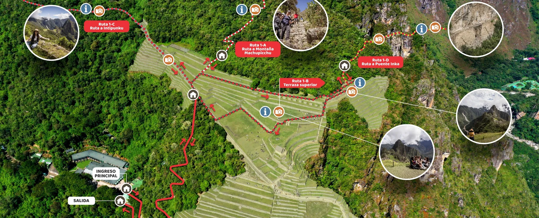
Circuit 1: The Panoramic Route
Circuit 1 stays above the city. It climbs the terraces to the Guardhouse, the viewpoint behind the famous postcard photo, and never goes down into the streets of the city. You look at Machu Picchu rather than walk through it.
Route 1-B: the upper terrace
- Route 1-B, there and back
- 1Entrance and exit
- 2GuardhouseUpper platform, the classic view
- 3Top of the terracesWhere the route turns back
© OpenStreetMap contributors
Route 1-B is the short version: up to the viewpoint and back, 1.6 km in total. The other three use the terraces as a gateway to a longer walk: Machu Picchu Mountain (1-A), the Sun Gate (1-C) and the Inca Bridge (1-D).

Circuit 2: The Classic Route
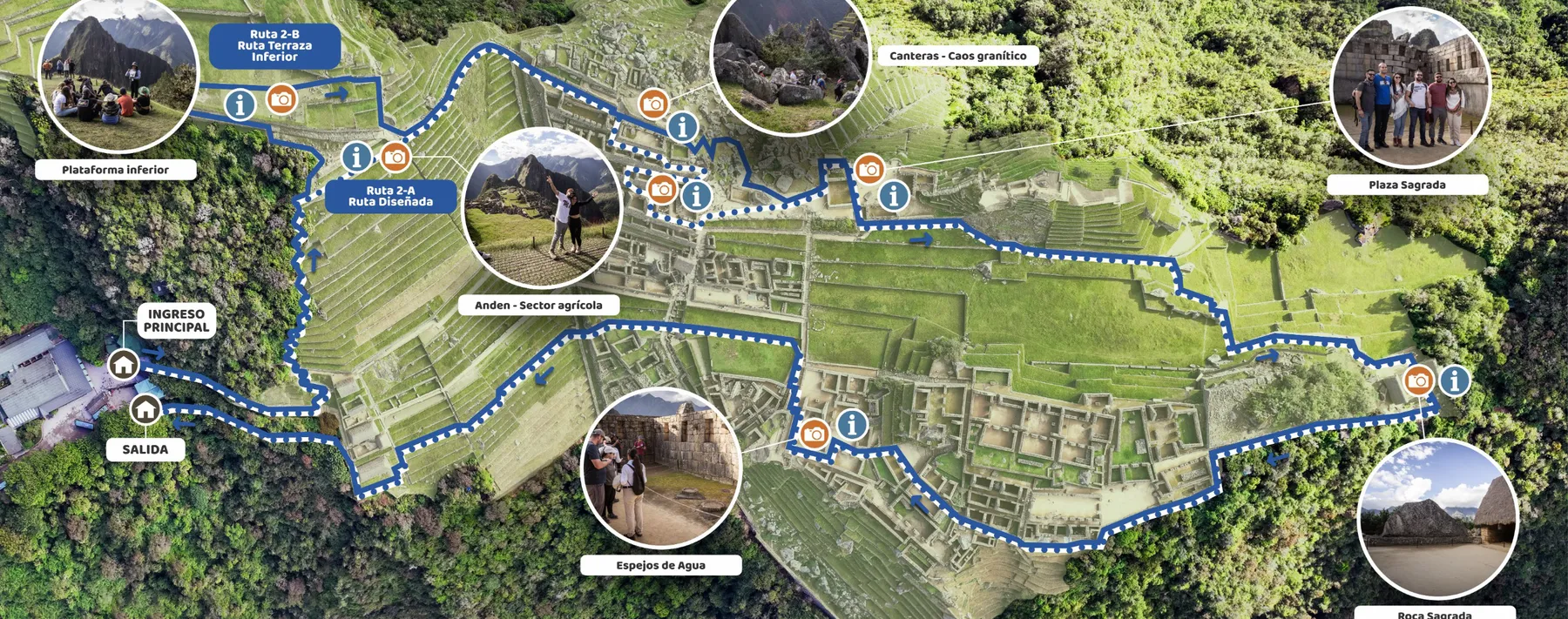
Circuit 2 is the complete visit, and the one we book for most travelers. It crosses the terraces, enters through the City Gate and covers both halves of the city: the temples above the Main Plaza and the houses below it.
Route 2-A: the designed route of the city
- Route 2-A, one way
- 1Entrance
- 2City Gate
- 3QuarryWith a view of the Temple of the Sun
- 4Sacred Plaza
- 5Sacred RockThe far end of the route
- 6Lower sector
- 7Temple of the Condor
© OpenStreetMap contributors
Route 2-A starts on the farming terraces, where you take the classic photo of the whole city, and runs about 2.5 km with a lot of stone stairs. It is our clear recommendation for a first visit. Route 2-B climbs a little higher first, to the lower platform below the Guardhouse, for 2.7 km in total.
Both allow 2.5 hours inside. Route 2-A has 1,400 places a day, 1,600 in high season, and still sells out first. Route 2-B, with 500 to 800, is the best alternative when 2-A is gone.
Circuit 2 tickets are the first to sell out. In the dry season, from May to September, book them as soon as you know your dates. Our Machu Picchu day trip includes Circuit 2 whenever the Ministry has space.
Circuit 3: The Royal Route
Circuit 3 stays in the lower part of the city. It passes beside the Temple of the Sun, the Royal Tomb and the House of the Inca, then the fountains, the Three Doorways and the Temple of the Condor. It is flatter and quieter.
Route 3-B: the royal sector
- Route 3-B, one way
- 1Entrance
- 2Temple of the SunFrom outside, with the Royal Tomb
- 3Three Doorways
- 4Water Mirrors
- 5Temple of the Condor
- 6Sacred RockStart of routes 3-A and 3-D
© OpenStreetMap contributors
Its weak point: no photo from above. You see the city from lower down, close to the houses, and you skip the Sacred Plaza. Its strength: the mountain routes. Route 3-A crosses the lower city to the Sacred Rock and climbs Huayna Picchu, and 3-C and 3-D branch off the same gate.
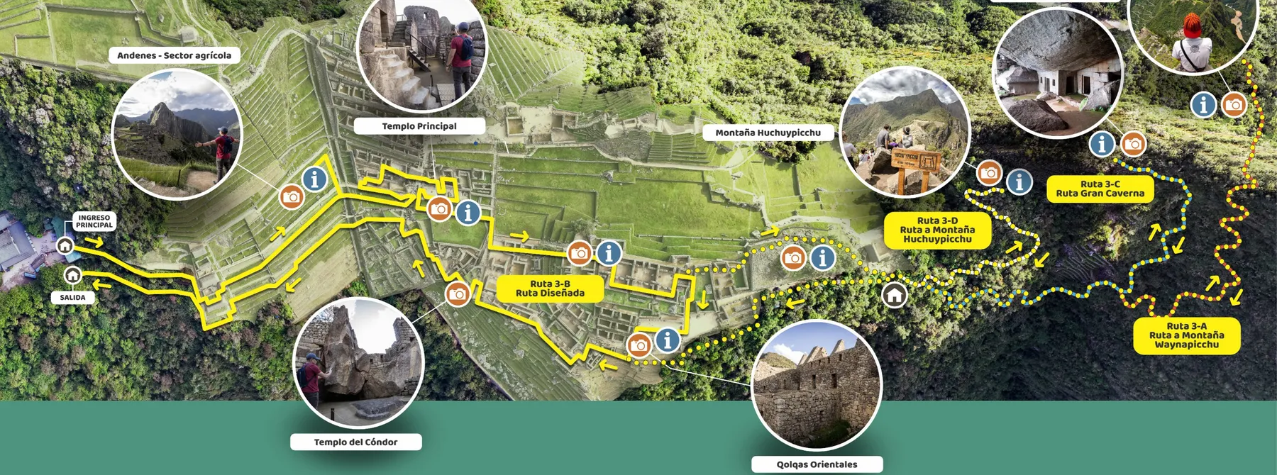

Route 3-B is also the most accessible. The Ministry rates it as the circuit with the least physical effort, and one stretch near the entrance is open to wheelchair users and visitors who need assistance.
Which Machu Picchu Circuit Is Best for You?
Most visitors only get one ticket, so the choice matters. This is what we tell our own travelers:
- First visit
Circuit 2, route 2-A
The classic photo and the whole city. If 2-A is gone, 2-B.
- Photographers
Circuit 1 plus Circuit 2
Route 1-B early for the postcard, then the city on Circuit 2.
- Hikers
Route 3-A or 1-A
Huayna Picchu is short and steep. Machu Picchu Mountain is longer and higher.
- Reduced mobility
Route 3-B
The flattest route, with an adapted stretch near the entrance.
- Short on time
Route 2-A or 3-B
Both fit in 2 hours if you have a train to catch.
- Inca Trail hikers
Route 3-B
Booked with the trek. Add a Circuit 2 ticket for the next day if you want more.
Where Huayna Picchu and Machu Picchu Mountain Fit on the Map
The two mountains close the ridge at each end. Huayna Picchu rises at the northern end, right behind the Sacred Rock. Machu Picchu Mountain rises at the southern end, above the terraces and the entrance.
The mountains and trails around the city
- Walking trail
- Bus road
- Railway
- Urubamba river
- 1Machu PicchuThe Inca city
- 2Huayna Picchu2,693 m, route 3-A
- 3Huchuy Picchu2,497 m, route 3-D
- 4Great CaveTemple of the Moon, route 3-C
- 5Machu Picchu Mountain3,082 m, route 1-A
- 6Inca BridgeRoute 1-D
- 7Sun Gate2,720 m, route 1-C
- 8Aguas Calientes
© OpenStreetMap contributors
| Peak | Height | Route | Entry |
|---|---|---|---|
| Huayna Picchu | 2,693 m (8,835 ft) | 3-A | 7 and 10 a.m., 400 a day |
| Machu Picchu Mountain | 3,082 m (10,111 ft) | 1-A | 7 and 9 a.m., 350 a day |
| Huchuy Picchu | 2,497 m (8,192 ft) | 3-D | 9 and 11 a.m., 40 a day, high season |
The Great Cave (route 3-C) admits 50 people a day at 8 and 9 a.m., in high season only. Huayna Picchu was closed from June 1 to 30, 2026 for maintenance.
You can't climb both on one ticket, and each mountain comes with only part of the city. After Huayna Picchu you tour the lower sector on Circuit 3. After Machu Picchu Mountain you see the terraces and the Guardhouse on Circuit 1. Tickets, entry times and the climb itself are in our Huayna Picchu guide.


Trail Map: the Sun Gate and the Inca Bridge
Two easier walks leave from the top of the terraces, both on Circuit 1 and both open only in the high season. They need no mountain ticket and show the city from angles few visitors see.
Sun Gate (Intipunku), route 1-C
The last stretch of the Inca Trail, climbing southeast to a stone gateway at 2,720 m. The route is about 3.4 km in total and takes about 2 hours there and back. Entry is from 7 to 10 a.m., for 130 people a day, with 4 hours on the ticket.

Inca Bridge, route 1-D
A flat path cut into a sheer cliff on the west side of the mountain, about 2.6 km in total and 1 hour there and back, with entry from 8 to 11 a.m. for 80 people a day. It ends at a gap the Incas crossed with removable logs, a back door to the city. You see the bridge from a viewpoint: crossing it is not allowed.
Where to Fly Into for Machu Picchu
Fly into Cusco, airport code CUZ. Machu Picchu has no airport, and almost every flight to Cusco connects in Lima, where international flights land. The hop from Lima to Cusco takes about 1 hour 20 minutes.
From the United States, nonstop flights reach Lima from cities such as Miami, Houston, Atlanta, Dallas, New York and Los Angeles. From Miami the flight takes about 6 hours.
- Leave time in Lima. Lima opened a new terminal in June 2025. Allow at least 3 hours to connect if you collect bags and pass immigration.
- Chinchero is not open yet. The new Cusco airport is expected in late 2027 or early 2028, according to Peru's transport ministry.
US passport holders need no visa for a tourist stay in Peru. Plan your first nights with the altitude in mind: Cusco sits at 3,399 m, so many travelers sleep lower in the Sacred Valley first.
Ways to visit Machu Picchu with us
 Machu Picchu Day TripFull day · EasyFrom $310
 Sacred Valley and Machu Picchu2 days · EasyFrom $390
 Classic Inca Trail 4 Days4 days · ChallengingFrom $750


Frequently Asked Questions
What country is Machu Picchu in?
Peru. It is in the Cusco region in the south of the country, about 75 km (47 miles) northwest of the city of Cusco.
Is Machu Picchu in the Amazon?
Not quite. It sits on the eastern edge of the Andes, in cloud forest where the mountains meet the Amazon basin. The Urubamba river below flows on to join the Amazon.
How many circuits does Machu Picchu have?
Three circuits with 10 routes, in force since June 2024. Circuit 1 is the panoramic one, Circuit 2 the full city and Circuit 3 the lower and royal sector.
Which circuit has the classic photo?
Routes 1-B, 2-A and 2-B. Route 1-B takes you highest, to the Guardhouse. On Circuit 3 you only see the city from lower down.
Can I visit more than one circuit?
Yes, with one ticket per circuit. A common combination is route 1-B early in the morning and Circuit 2 later the same day.
Which circuit includes Huayna Picchu?
Circuit 3. Route 3-A climbs Huayna Picchu and route 3-C continues to the Great Cave. Both cross the lower city first.
How long can I stay inside Machu Picchu?
2.5 hours on the standard routes. The routes with a mountain or a trail allow 3 to 7 hours, as printed on the official map of each route.
Is there a road to Machu Picchu?
Only the bus road from Aguas Calientes to the entrance. No road connects Cusco with Machu Picchu, so you arrive by train or on foot.
How we checked this guide
This guide comes from what we see while guiding these routes every week. Prices, schedules and rules were checked against the official sites below.
We sell the Machu Picchu tours linked on this page and book their circuits with the Ministry of Culture. Routes, times and prices come from the Ministry's official maps and were checked on the date above.
- Ministry of Culture, circuits and visiting routes (official maps of each route)
- Ministry of Culture, official ticket site
- UNESCO World Heritage Centre, Historic Sanctuary of Machu Picchu
- OpenStreetMap, trails and ruins of the sanctuary
Last checked:

Jorge Suyo
Director and trekking guideJorge Suyo is a trekking guide and the person who leads Inca Outdoors. He knows these trails from walking them with groups, and that experience shapes how each trip is planned.
Meet the team

